

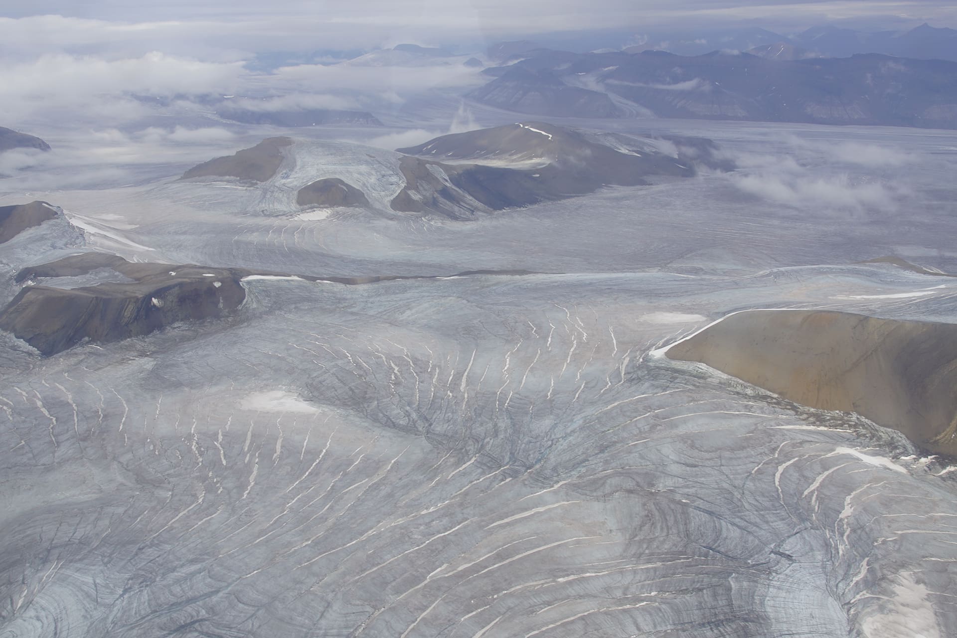
The summer of 2024, the hottest on record, pushed the limits of what we thought possible in the Arctic. In Svalbard, glaciers melted on an unprecedented scale: across the entire archipelago, around 1% of the total ice mass disappeared in a single season. What does that mean for Svalbard—and for us?
By: Halfdan Pascal Kierulf and Carl William Lund // Norwegian Mapping Authority
Thomas Vikhamar Schuler // University of Oslo
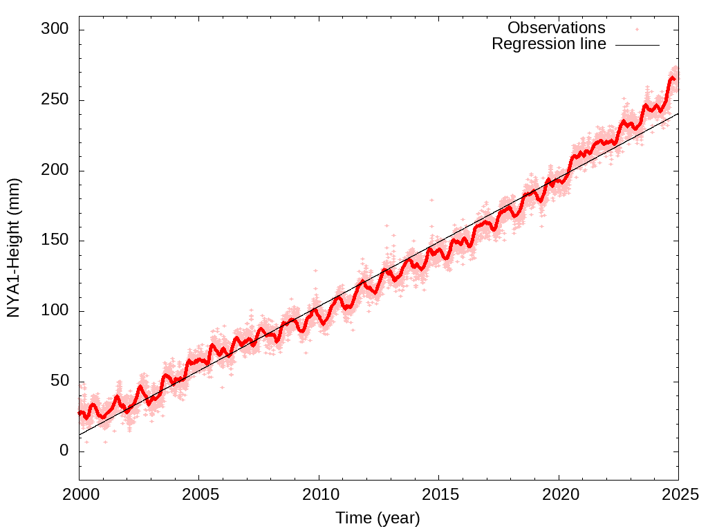
When glacier ice disappears, the pressure on the earth’s crust is relieved and the ground rises. This is happening faster than in the past, and measurements from the Norwegian Mapping Authority’s Geodetic Earth Observatory show that the land around Ny-Ålesund rose by almost two centimetres between July and October 2024.
Movements of a few millimetres may be imperceptible to the casual observer, but have major implications for maps, property boundaries and a global navigation system that relies on millimetre precision. The land uplift caused by the extreme glacier melt in Svalbard during the summer of 2024 was so substantial that it affected the global frame of reference, i.e. the coordinate system used to describe exact positions on Earth, and thus also global Earth observation.
The land uplift seen in 2024 was basically a natural reaction to an abnormal situation. But when a changing landscape conflicts with society’s need for stable boundaries, accurate maps and reliable navigation systems, national agencies must take action. Svalbard reminds us that climate change not only melts ice, but also alters the parameters on which we base our systems.
Hinted at end-of-century conditions
Svalbard’s summer heatwave in 2024 resulted in significant glacier melting. The ice mass loss was quantified by a combination of ground observations, modelling and remote sensing. The results indicated an ice mass loss of around 61.7 gigatonnes, of which 42.1 gigatonnes were from the surface balance (the balance between snowfall and melting) and the remaining 19.6 gigatonnes were lost as calving icebergs. In total, this corresponds to approximately 1% of Svalbard’s total glacier mass, and is comparable to the total loss of ice mass from the Greenland ice sheet in 2024, even though the latter is fifty times larger. Glacier mass loss contributes to global sea level rise and has potential impacts on fjord circulation and marine ecology, as well as on native wildlife and local communities.
The meltdown exceeded all previous records by a wide margin. All parts of Svalbard experienced mass losses at a level that is expected to occur in the current climate (1991-2020) only once in a few hundred or perhaps thousand years. The unprecedented land uplift measured in Ny-Ålesund in the summer of 2024 has similar likelihood statistics and was used for independent confirmation of the huge mass loss.
Much of the melt occurred during a six-week period when a steady weather pattern resulted in temperatures well above normal. Although such conditions are extremely rare under prevailing climatic conditions, climate models suggest that temperatures this high may be commonplace by the end of the 21st century. The summer of 2024 in Svalbard is thus a harbinger of widespread melting of Arctic glaciers in coming decades.

Geodetics in a dynamic Svalbard
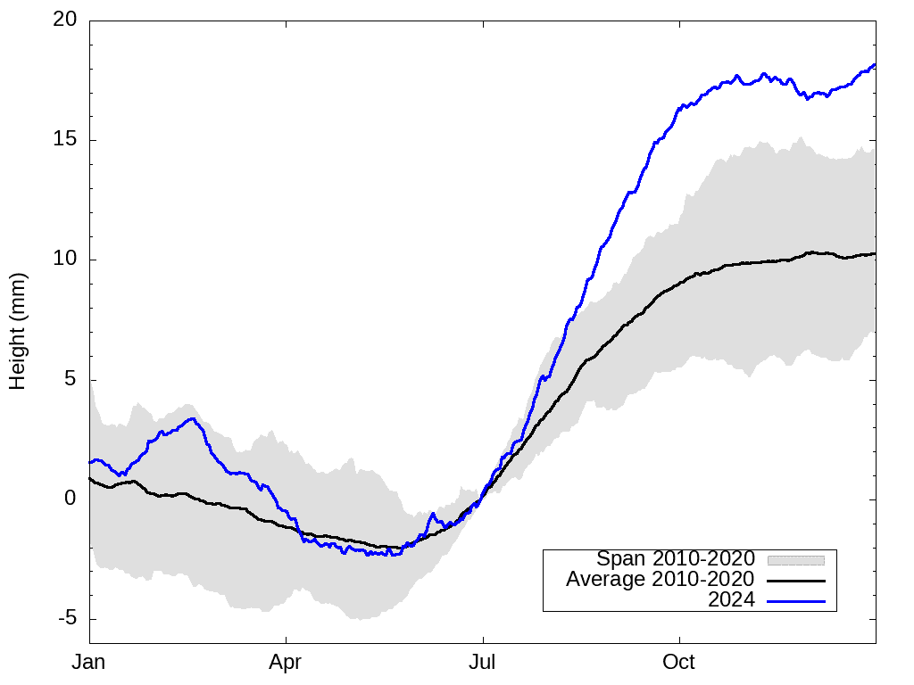
In Scandinavia, land uplift or rebound is a well-known phenomenon. As ice retreated at the end of the last ice age, the land reacted by rising. This slow process, which can still be observed 10,000 years after the ice disappeared, is termed isostatic rebound. The colossal ice mass changes seen in Svalbard today are having a more rapid effect. When the glaciers melt, the pressure on the bedrock is released, causing immediate uplift. In the summer of 2024, the ground uplift was two centimetres in three months, twice the uplift in a normal summer. Through the winter, we see the opposite: the ground is forced down a few millimetres as the snow settles.
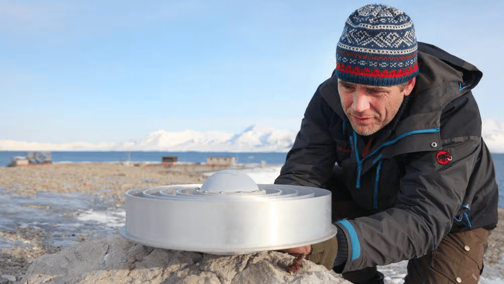
These changes have a direct consequence. Land uplift affects the very basis for measuring the earth, termed the geodetic basis. The Geodetic Earth Observatory in Ny-Ålesund, northwest Svalbard, is one of the most important in the world for monitoring the earth’s rotation and movements in the earth’s crust. Here we receive signals from quasars billions of light years away, transmit laser pulses to satellites, and use GPS and similar techniques to continuously record movements in the earth’s surface. When the ground suddenly rises faster than normal, we must correct for the changes, otherwise the deviations can propagate throughout the entire earth observation system, making positioning and navigation less accurate. To increase our knowledge of the changes taking place, the Norwegian Mapping Authority is working to expand the global navigation satellite system network in Svalbard.
GPS is used in many essential systems such as aviation, shipping, power supply, emergency response, mobile communications and environmental monitoring. Stability and precision are not merely nice to have, but also essential societal infrastructure. This makes Svalbard, with its rapid and measurable ice mass loss, one of the best places in the world to gain understanding of how the earth’s crust reacts to climate change, and to generate knowledge essential for the global precision we all depend on.
Minor uplifts, major consequences
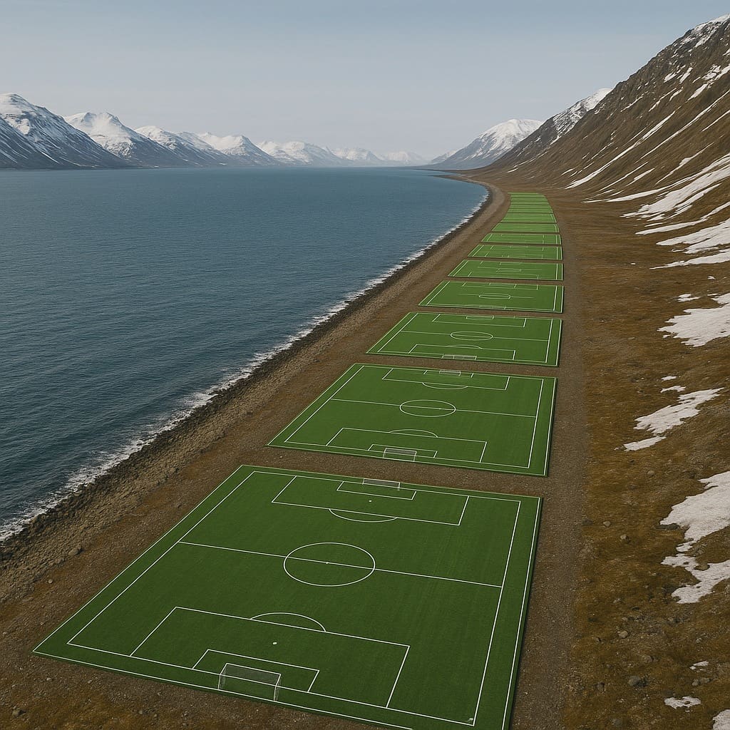
Using detailed terrain models for Svalbard, we did an experiment to visualise the measured land uplift. By calculating the average slope along the entire coast of Svalbard, it is possible to predict how much potential new land area rose from the sea around Svalbard in summer 2024. Assuming that the land uplift was uniform along the entire coast, the archipelago would have gained new land area equivalent to almost 150 football pitches. This is not an actual future scenario, but serves to illustrate how climate change can shift coastlines.
Changes to a coastline can have long-term consequences for maps, but legal and administrative issues also arise out of a mobile landscape. The Nordic region has useful parallels such as in Iceland, where volcanic eruptions can create new land, and one issue might then be who owns that land. In Denmark, severe erosion has resulted in private properties losing land, while the land register map still shows the property line far out to sea.
This demonstrates that even small uplifts can be significant. Foreshores change, shallows dry out, and river deltas flow into new distributaries. When permafrost meets sea level in new configurations, beaches and slopes take on a different shape. The sum of all such small adjustments will shape the Svalbard of tomorrow.
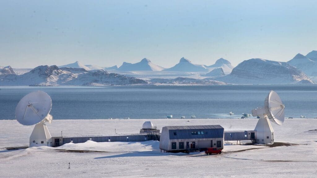
Norwegian Geodetic Earth Observatory, Ny-Ålesund, Svalbard
The Geodetic Earth Observatory in Ny-Ålesund is the northernmost facility of its kind and is part of a worldwide geodetic observation and research network. From the new observatory, the Norwegian Mapping Authority measures the earth’s movement and position using several geodetic measurement techniques at the same location.
Further reading
Schuler TV, Benestad RE, Isaksen K, Kierulf HP, Kohler J, Moholdt G, Schmidt LS (2025) Svalbard’s 2024 record summer: An early view of Arctic glacier meltdown? Proceedings of the National Academy of Sciences 122(34): e2503806122,
Kierulf HP, Kohler J, Boy J-B, Geyman EC, Mémin A, Omang OC, Steffen H, Steffer R (2022) Time-varying uplift in Svalbard – an effect of glacial changes. Geophysical Journal International 231(3): 1518–1534
Kierulf HP, Lund CW (2025) Svalbard kan ha vokst med 148,5 fotballbaner. [Svalbard may have grown by 148.5 football pitches.] Norwegian Mapping Authority website.
(In Norwegian)
Acknowledgements
This article summarises the findings presented in Schuler et al 2025, which was co-authored by scientists from the Department of Geosciences at the University of Oslo, the Norwegian Meteorological Institute MET, the Norwegian Mapping Authority, and the Norwegian Polar Institute.
The study was funded by the Research Council of Norway through the projects Nansen Legacy (NFR 276730), MAMMAMIA (NFR 301837) and LIQUIDICE (EU Horizon Europe research and innovation programme, Grant 101184962).
Parts of the study were funded through the BarentsCryoClim project (Norwegian Climate and Environment Agency) and FRAM CLEAN (Cumulative impact of multiple stressors in High North ecosystems).