

Svalbard’s cultural heritage and infrastructure face increasing risks as climate change accelerates permafrost thaw and ground instability. The PermaRICH project unites experts across disciplines to evaluate these risks, and guide stakeholders’ prioritisation of adaptation and mitigation measures.
By: Line Rouyet, Elisabeth Angell, Lotte Wendt and Tom Rune Lauknes // NORCE Research AS
Norwegian Polar Institute
Ionut Cristi Nicu, Lise Loktu and Alma E Thuestad //Norwegian Institute for Cultural Heritage Research
Lena Rubensdotter // Geological Survey of Norway
Anatoly Sinitsyn and Yared Bekele // SINTEF AS
Hanne H Christiansen1, Maaike F Weerdesteijn and Matthieu Leydier // University Centre in Svalbard
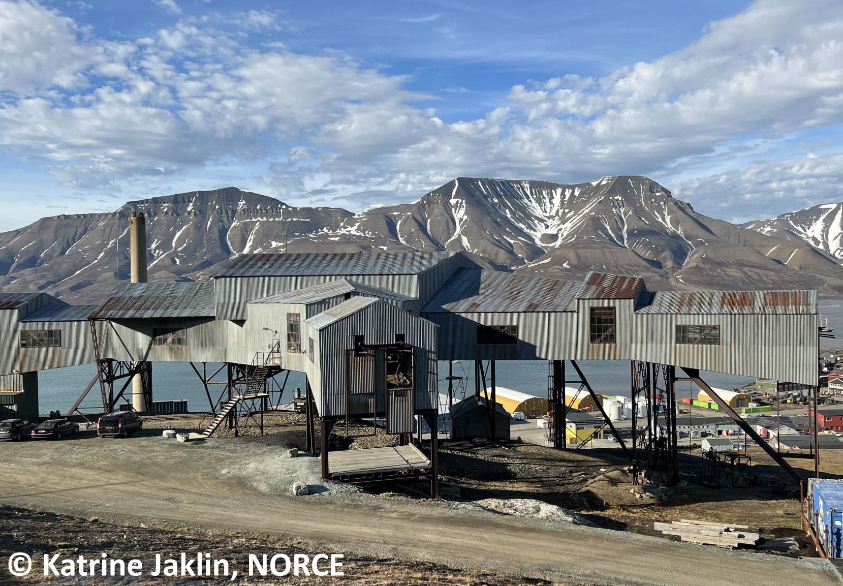
Svalbard holds a rich cultural heritage, with remains from whaling, trapping, exploration, mining, and military activities. These traces form one of the most intact historical archives in the European High Arctic, providing unique insights into past human–environment interactions. Human activity is still extensive today, especially in and around Longyearbyen, Barentsburg, and research stations, such as Ny-Ålesund.
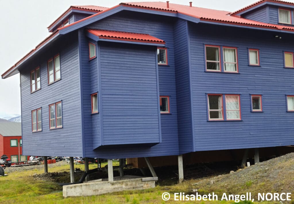
Svalbard’s landscape is underlain by permafrost—ground that remains frozen year-round. The overlying active layer thaws each summer, which can cause the surface to sink as ground ice melts. As the Arctic warms, permafrost degradation and active layer thickening intensify ground movement and related hazards, both on slopes and in flat terrain.
For the past three years, the Fram Centre PermaRICH project has studied how permafrost processes and ground movement may affect cultural heritage sites and modern buildings in Svalbard. The project brings together experts from several disciplines—geology, geography, Earth observation, civil engineering, archaeology, and social sciences—to produce new results describing the permafrost conditions, ground dynamics, and their potential consequences in and around Longyearbyen and Ny-Ålesund.
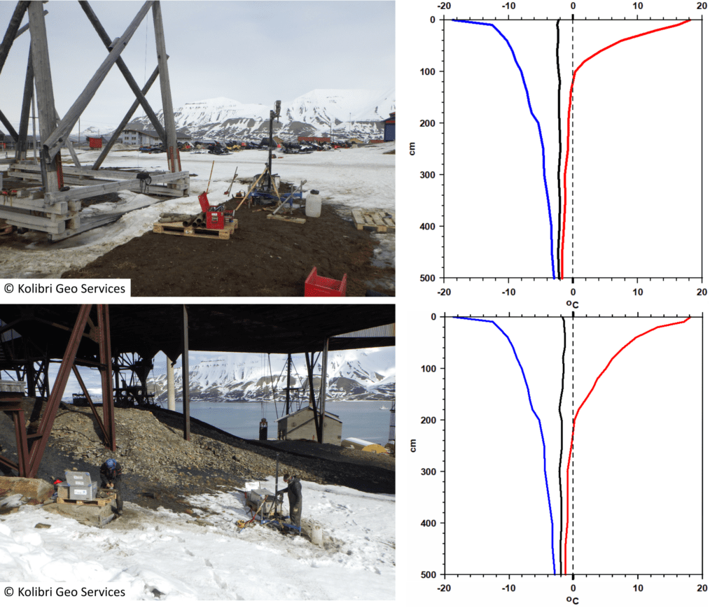
PermaRICH permafrost monitoring activities in Longyearbyen
Upper row: Borehole being drilled next to a cableway trestle in
spring 2023 (left), and the ground temperatures measured in
2024–2025 (right).
Lower row: Borehole being drilled under the old coal cableway
hub in spring 2023 (left), and the ground temperatures measured
in 2024–2025 (right). Maximum (red line), average (black line) and
minimum (blue line) values.
Horizontal axis: ground temperature;
vertical axis: depth.
Graphs: Hanne H Christiansen / Aarhus University and University
Centre in Svalbard
Permafrost thaw and risk governance
The Norwegian Parliament and the Government devote limited attention to permafrost thaw, although the most recent White Paper on Svalbard (Meld. St. 26 (2023-24)) and a few other documents mention this topic. Norway does not have an agency with overarching responsibility for risk management related to permafrost thaw. While the Norwegian Water Resources and Energy Directorate has responsibility for geohazard monitoring and early warning, the Environment Agency oversees climate adaptation, and the Directorate for Civil Protection oversees preparedness. State sectoral agencies have case-specific responses to threats from thawing permafrost, which depend on their respective mandates. For instance, Statsbygg (which manages government property) focuses on adaptation and mitigation solutions for buildings, Avinor’s interventions target risk affecting airport infrastructure, and the Directorate for Cultural Heritage pays attention to the risks imposed by climate change on cultural monuments.
Svalbard authorities, such as the Governor of Svalbard and the Longyearbyen Community Council, show awareness of this topic, considering permafrost thaw in emergency preparedness and climate-related risk assessment. However, high turnover among both residents and public officials limits institutional memory. This challenge increases the need for a comprehensive national approach and support in this field. The agencies with long experience in Svalbard have valuable knowledge to share. Improved coordination between agencies and consistent follow-up of responsibilities would benefit local stakeholders and contribute to a more effective risk governance.
Permafrost conditions in Longyearbyen
In Longyearbyen, continuous measurements of permafrost temperatures began only in 2019. Until recently, the permafrost conditions directly beneath cultural heritage objects had not been systematically measured. Thanks to PermaRICH, boreholes down to 5 m were drilled at one cableway trestle and at the old coal cableway hub, both located centrally in Longyearbyen.
We aimed to collect ground samples at these study objects to understand how the permafrost will react in a warming climate. The ground beneath the cultural heritage sites appeared to be much looser and more disturbed than natural sediments in other parts of Longyearbyen, where cores had been collected previously. Therefore we were unable to collect frozen cores for analyses. This lack of success at coring indicates a relatively low ice content, and suggests that future permafrost thaw is unlikely to cause large-scale sinking at these locations.
Temperature sensors were installed in the boreholes, and the measurements show that the permafrost in these areas is relatively warm, between 1.3°C and 1.7°C at 5 m depth. The active layer is about 1–2 metres thick, which is within the average for the Longyearbyen permafrost boreholes.
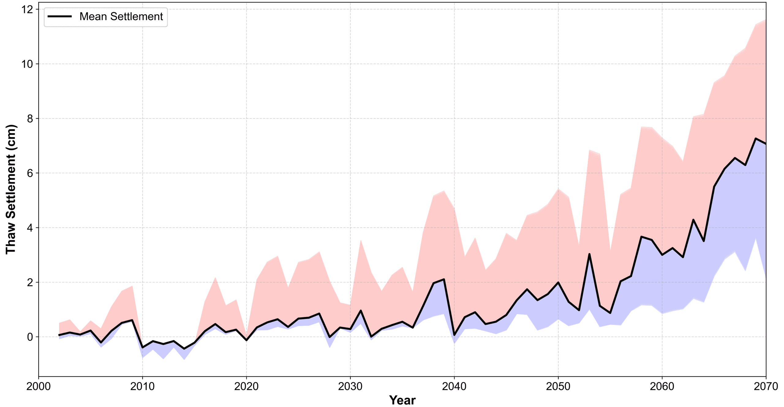
Predicted evolution of the thaw settlement in Longyearbyen
The thaw settlement remains relatively low and stable until around 2040, after which it begins to increase steadily, with a notable rise in both the mean value (black line) and the variability (shaded
area). By 2070, the settlement might exceed 10 cm based on the most extreme scenarios.
Graph: Yared Bekele and Anatoly Sinitsyn / SINTEF AS
Climate projection and settlement
We studied how climate change, thawing permafrost, and melting ground ice could affect the stability of buildings and cultural heritage sites in Longyearbyen and Ny-Ålesund. Climate projections indicate steady warming through 2070, leading to thicker active layers and higher permafrost temperatures. We examined how these changes may influence two main types of processes: thaw settlement, which happens when ground ice melts, and creep settlement, which is the gradual deformation of frozen soil under a sustained weight. These effects were studied for buildings with different foundation types.
The results show that the active layer will get thicker, causing more thaw settlement of the ground. For buildings on piles, the part of the piles that stays frozen will get shorter, reducing how much load they can safely hold. Creep settlement is smaller but still adds to the total movement. For shallow foundations, both thawing and creeping may cause more noticeable settlement. Overall, the study shows that ground deformation due to climate warming could threaten the long-term stability of structures in Svalbard.
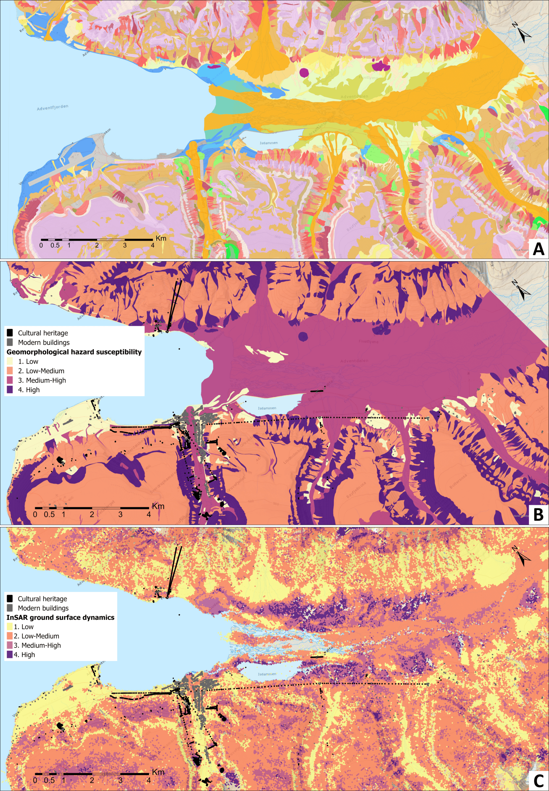
New maps for hazard assessment in Longyearbyen and Adventdalen
A) New geomorphological map following the Norwegian SOSI-standard for Quaternary geological maps, with adaptation to the Arctic setting and the PermaRICH objectives.
B) Four levels of geomorphology-based susceptibility to permafrost-related hazards (low-high).
C) InSAR simplified map showing four levels of ground dynamics (low-high) from seasonal and interannual surface movement.
Maps: Lena Rubensdotter / Geological Survey of Norway and Line Rouyet / NORCE
Assessment of natural hazards
A wide range of natural processes can endanger cultural heritage and modern buildings in permafrost terrain, such as subsidence due to ground ice melt, landslides, rockfall, debris flows, floods, erosion along rivers and coastlines, etc. The first step of any hazard analysis is to map the type, location, and distribution of processes and surface material. We used modern aerial images, old maps and field visits to create new geomorphological maps that show the distribution of landforms, processes, and deposits. These maps were then used to make indicators documenting where permafrost-related processes might pose threats to cultural heritage and buildings.
In addition, we used an advanced measurement technique, called InSAR, that compares satellite images taken at different times, to measure how the ground surface is moving through the summer and from one year to another. Together, the geomorphological and the InSAR ground movement maps form a base that enables a combined evaluation of several natural hazard types. The maps on page X illustrate some of the new data for the Longyearbyen and Adventdalen area. Similar datasets have been produced for Brøggerhalvøya and Ny-Ålesund.
Vulnerability assessment
Vulnerability is defined as the likelihood that a person or an object could be harmed when something dangerous occurs. We analysed 639 cultural heritage sites and 1028 modern buildings in and around Longyearbyen, and 90 cultural heritage sites and 128 modern buildings in Ny-Ålesund. In PermaRICH, we have developed a qualitative score from 1 (low) to 4 (high) to document the level of sensitivity of the studied sites and buildings.
The criteria used to evaluate the potential for damage are different for cultural heritage and for modern buildings. For cultural heritage, we analysed the type, shape and material of the protected historical remains. We evaluated how each category would be affected by permafrost-related hazards. For modern buildings, vulnerability was determined by usage and community function. Some overlap exists. Some heritage buildings are still in use today and were therefore assessed using both frameworks, reflecting different factors for analysing vulnerability in terms of historical value and population exposure.
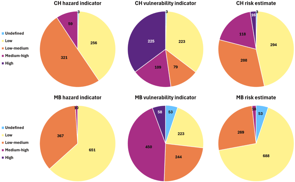
Hazard, vulnerability and risk qualitative estimates in Longyearbyen
Such results can also be viewed on a map, to analyse specific locations or
focus on objects with the highest scores.
Upper row: Distribution of the indicators for 639 cultural heritage (CH) sites.
Lower row: Distribution of the indicators for 1028 modern buildings (MB).
Similar estimates have been developed for Ny-Ålesund.
Graphs: Ionut Cristi Nicu / Norwegian Institute for Cultural Heritage Research,
Line Rouyet / NORCE, and Lena Rubensdotter / Geological Survey of Norway
Integrated risk assessment
Risk is defined as the likelihood that something bad happens, based on how dangerous a situation is and how vulnerable the people or objects are. In PermaRICH, we developed an indicator combining the results of the permafrost-related hazard analysis and vulnerability assessment. The risk estimate is qualitative and relative. It is a way to summarise the information, to complement local knowledge and other management criteria when prioritising concrete measures. The risk estimates will be communicated to the local stakeholders, together with all initial maps and intermediate indicators, so that the results can be tailored to different applications.
Conclusions and prospects
The PermaRICH project gathers and analyses a wide range of new information on permafrost, natural hazard and risk in Svalbard. The team is now working to make all data and results freely available, so they can be drawn upon by local users in Svalbard. We hope that our work will contribute to the management of valuable historical sites, and support suitable solutions for improving public safety and maintaining sustainable economic activity in Svalbard.
Further reading
Bekele Y, Sinitsyn A (2025) Evaluation of foundation settlements for selected cultural heritage structures under climate change impacts. SINTEF report 2025:00370. ISBN: 978-82-14-07476-5
Angell E (2024) Myndigheters policy om tining av permafrost og skred i Longyearbyen. Report no. 1, NORCE. (In Norwegian with brief summary in English).