

Ship traffic in the High Arctic grew between 2013 and 2022. There are huge differences between different Arctic seas in terms of total activity, growth rates, seasonal variation and types of vessels.
By: Gunnar Sander // Norwegian Institute for Water Research
Eirik Mikkelsen // Nofima
Signals from Automatic Identification System (AIS) transmitters on ships generate huge datasets that have revolutionised the ability to analyse ship traffic. The Arctic Council has developed the Arctic Ship Traffic Database (ASTD), building on a system from the Norwegian Coastal Administration (Kystverket). This offers the general user many options for generating statistics for traffic in areas, over crossing lines, and in ports. The core of these geographical definitions is a heritage from work by the authors of this article arising from a collaboration between the Coastal Administration and the Fram Centre. In an analysis of traffic patterns for the first decade of ASTD operations, we have both tested the utility of the system and provided an analysis of traffic developments.
It is a common assumption that reduced sea-ice cover will increase ship traffic. Finding out how much the traffic grows, however, depends on geographical definitions. A very relevant delimitation is the area of the International Maritime Organization’s Polar Code, which addresses the peculiar challenges for ships operating near the poles. Within its Arctic boundary, the distance sailed by ships increased from 6.1 million nautical miles (nm) per year in 2013 to 12.1 million nm in 2022, equivalent to 8.7% average annual growth.
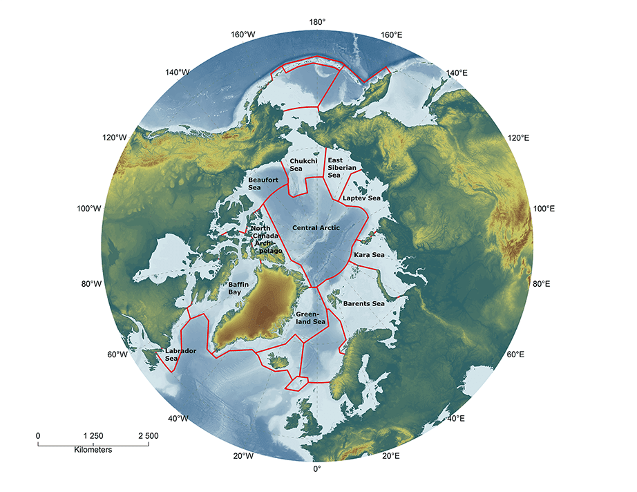
Unfortunately, it is not possible to analyse the huge internal differences within the Polar Code area since there is no agreed definition of how it can be subdivided. To understand spatial variability, we were confined to comparing traffic in High-Arctic Large Marine Ecosystems (LMEs). When LMEs are used, areas south of the boundary of the Polar Code are included, which is why the total traffic we show here is 22.2 million nm in 2022, nearly twice as much as in the Polar Code area.

Vessels in the Barents Sea accounted for 74% of the total distance sailed in the High-Arctic LMEs in 2022. At the opposite end, the traffic in the Northern Canadian Archipelago was lowest with 0.01% of the total, while the Central Arctic Ocean had a 0.1% share.
Over the decade 2013–2022, traffic has grown in all the LMEs, but very unequally. In the Barents Sea, vessels sailed 4.5 million nm further in 2022 than 10 years before, making the growth there the largest. As a contrast, the traffic in the Northern Canadian Archipelago increased by only 0.002 million nm. The traffic in the Central Arctic Ocean also grew, but was primarily characterised by large variation between years. A remarkable change was the tripling of the sailed distance in the Kara Sea, making this LME number two in 2022 traffic with a 7.8% share of the distance sailed, slightly before Baffin Bay with 7.3%.
Looking into the types of vessels that operate gives an indication of what types of activities create the traffic. It also gives a first indication of the impacts and risks involved. To understand this in depth, data on traffic need to be supplemented with knowledge on, for instance, emissions, catches, and risks of accidents involving people (cruise ships) or creating large-scale pollution (oil tankers).
The type of traffic in the various regions also varies considerably. In the Barents Sea, fishing vessels constitute such a big part of the traffic that fishing vessels become the dominating ship type for all the High-Arctic LMEs. Fisheries are important in Baffin Bay too. There, the traffic also contains a significant proportion of medium-sized container vessels that serve the settlements in Greenland and northern Canada, and larger bulk carriers that transport iron-ore from a big mine on Baffin Island, which opened in 2015. In the Kara Sea, there has been steady growth in traffic with cargo ships. Such vessels are important in delivering goods and equipment for the construction of oil and gas projects, with related infrastructure. The development of large-scale petroleum projects on the Yamal Peninsula has been followed by the introduction of crude oil and gas tankers of a size and type that had never been present in the Arctic before. There are low shares of fishing vessels, cruise vessels and container ships north of Russia.
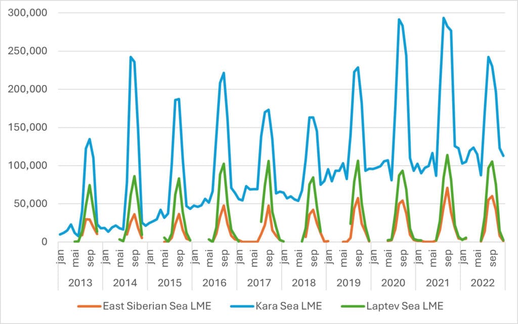
For ship traffic in the Arctic to grow substantially, there is a need to overcome the barriers created by winter conditions. Despite climate change, the traffic is still highly seasonal, concentrated to a few summer months, dropping in winter to almost zero in the areas with harshest climate. Again, the Kara Sea is a remarkable exception. The Russians have upgraded their fleet of icebreakers and supporting infrastructure, and the fleet of ships transporting oil and gas are ice-classed.
A major reason for the public and political interest in Arctic shipping lies in the vision of the Arctic becoming a corridor for intercontinental traffic, primarily between Europe and Asia. The ASTD can only give some clues, indicating few transits. Other sources can tell that even before the Western sanctions following Russia’s full-scale attack on Ukraine, the transit traffic through Russia’s Northern Sea Route was lower than one day’s traffic in the Suez Canal. It dropped from 85 transit voyages in 2021 to 43 in 2022, most likely because of the sanctions. As long as the war and the sanctions continue, it is unlikely that Western ships will engage in transit traffic through Russian waters.
Intercontinental shipping therefore seems to be an unrealistic driver for the growth of Arctic shipping for the near future. Despite this, our analysis illustrates that all kinds of economic activities within the Arctic can create growth in shipping, either internally in the Arctic, or between Arctic destinations and ports outside the Arctic.
Further reading
Sander G, Mikkelsen E (2025) Arctic shipping 2013–2022: the traffic has grown, with big variation between regions, seasons and ship types. Polar Research 44,