

Marine seismic surveys use high-intensity low-frequency underwater sound waves to map sub-seabed structures, such as oil reservoirs. These sound waves travel long distances, requiring large-range measurements to assess their environmental impact, including potential disturbance of marine fauna.
By: Virginie Ramasco and Katherine Dunning // Akvaplan-niva
Geir Pedersen and Tonje Nesse Forland // Institute of Marine Research
Seismic surveys are frequently used for oil and gas (O&G) exploration, exploitation, and monitoring, not least in the North Sea, where many marine animals also live. The Glider II project, run by Akvaplan-niva in collaboration with an industrial O&G company, was aimed at investigating if the use of autonomous glider platforms for applied scientific research could support operational challenges in the O&G industry. One of the sub-objectives of the project was to test if gliders could be used in passive acoustic monitoring of seismic operations. Passive acoustic measurements can be helpful in studying the sound propagation from the source, the exposure levels at different distances and, ultimately, the impact of such exposure on marina fauna.
Graph: Virginie Ramasco / Akvaplan-niva
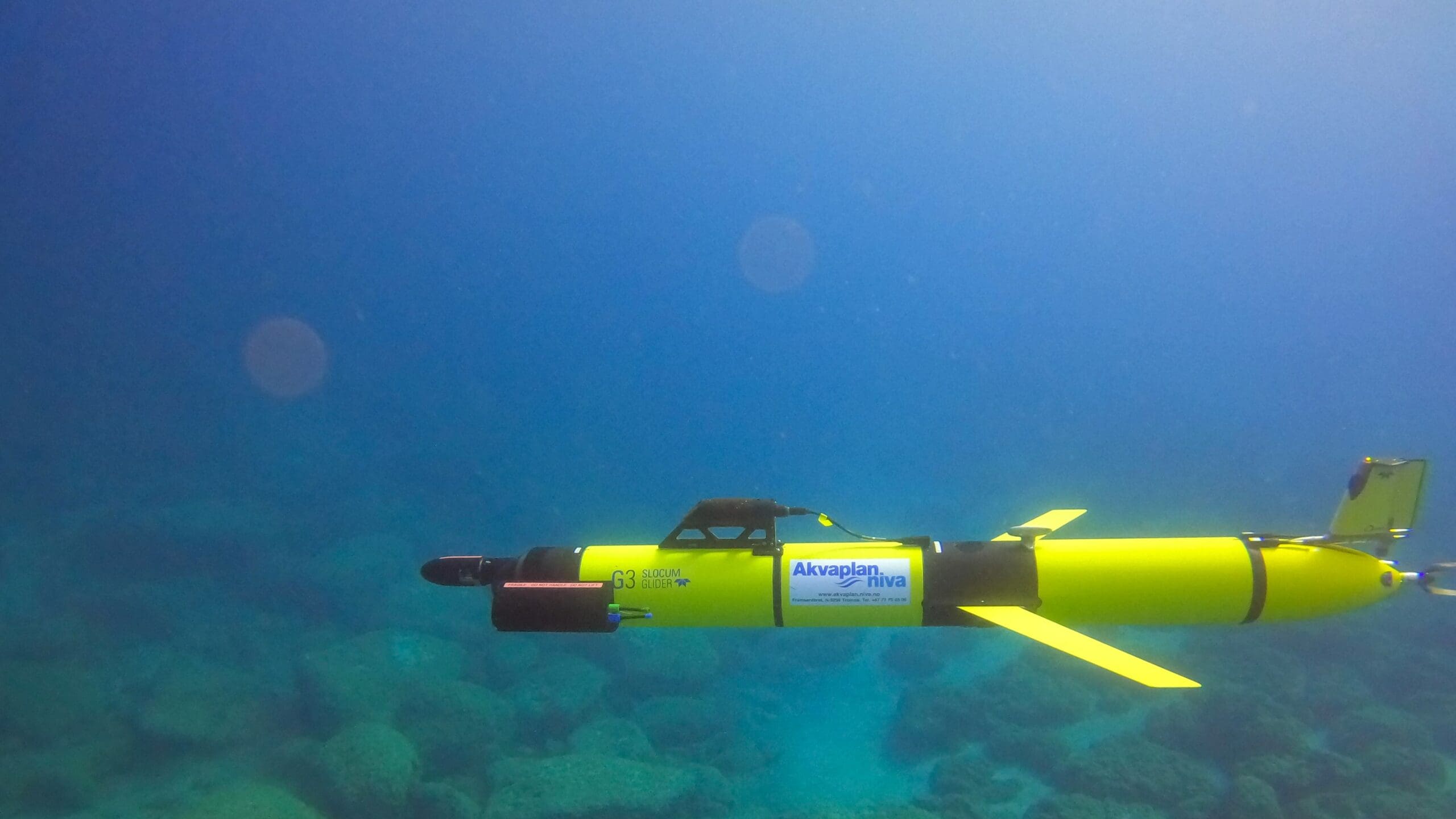
For this purpose, a subsea glider equipped with a hydrophone was deployed during one of the regular seismic surveys performed by the O&G industry to monitor the status of the reservoirs at an extraction site in the North Sea. Around these O&G installations, a seismic survey is regularly performed in an area of ~12 x 8 km. During these surveys a seismic vessel operates continuously for several weeks running up and down parallel survey lines within that area, performing seismic shots every 25 metres (about every 10 seconds) to map the underground reservoirs.
During the seismic survey in spring 2022, Akvaplan-niva’s autonomous subsea glider was used to measure the sound levels throughout the water column between ~20 and ~120 km distance from the operating seismic vessel (i.e. the sound source). The objective was to assess whether seismic shots could be reliably detected above background noise levels at such distances. We also wanted to test if this vehicle was a reliable platform for this purpose under operational conditions.
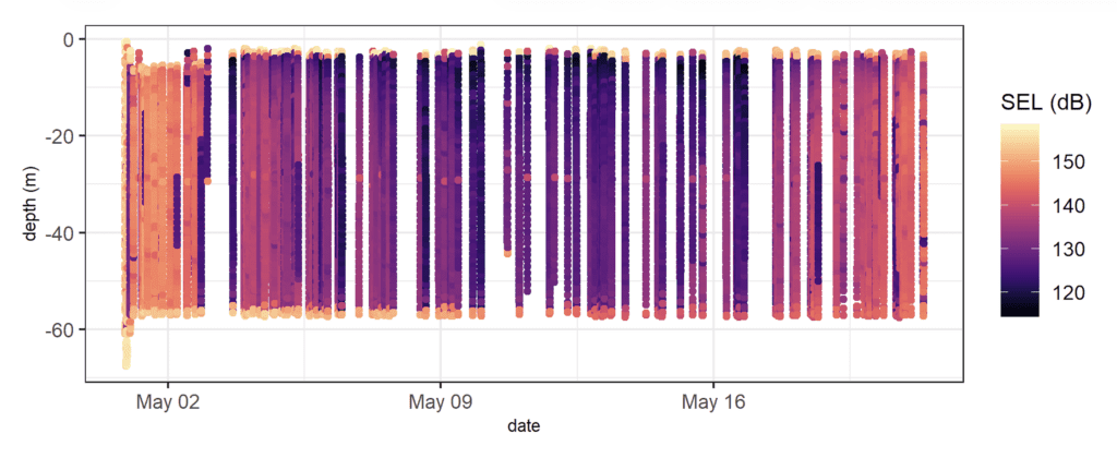
After recovery of the glider, the sound measurements were downloaded and analysed to evaluate the main sources of noise interference and to isolate the sound attributable to the seismic shots. Subsea gliders are very silent platforms highly suitable for passive acoustic monitoring. However, due to internal changes in buoyancy and pitch, they do produce some noise. The noise usually occurs during the shifts between downward and upward gliding or vice versa. These shifts mostly take place near the ocean surface and at maximum diving depths; thus most of the internal noise was at specific depths, which made it easier for the scientific team to identify and eliminate noise by filtering the data from those depths.
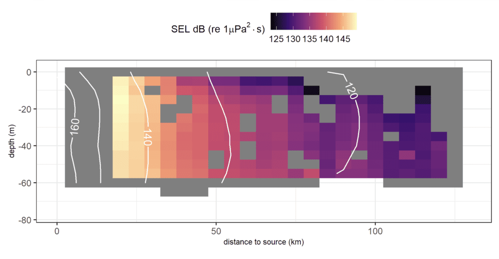
Sound Exposure Levels (SELs) were calculated from the cleaned data. These are a measure of the sound intensity integrated over a period of time. In this example 10 s was used as integration period, which roughly corresponds to the time between subsequent shots. SELs provide a quantification of the marine habitat exposure to sound and are important in environmental impact assessments.
Graph: Virginie Ramasco / Akvaplan-niva
Graph: Virginie Ramasco / Akvaplan-niva
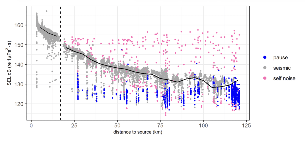
An estimate of the general background noise of the area was done by calculating SELs in periods where seismic activity was paused. This occurred regularly throughout the survey. The sound above background noise during periods of active seismic shooting was attributed to seismic activity. The resulting classification of estimated SELs over time was compared to a nearby moored hydrophone for quality assurance. SELs showed a realistic decaying pattern with distance from the sound source and were consistent with the absolute values measured by the hydrophone at the mooring.
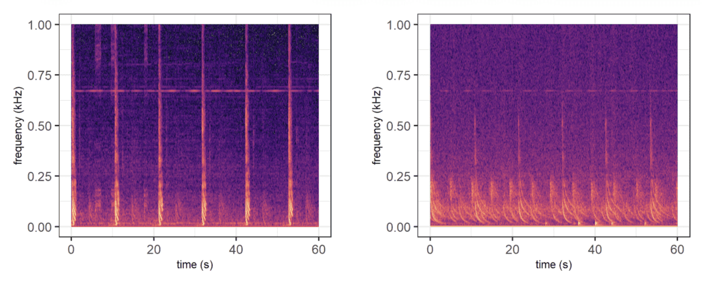
Seismic shots were identifiable in the spectrograms (i.e. images of the sound intensity by frequency and time) at both ~20 km and ~120 km distance. At 20 km, shots are visible as separate higher intensity sounds at 10-second intervals. At 120 km, sound waves from the same shot arrive at the receiver (i.e. hydrophone on the glider) at different times due to reflections and refractions on their path; hence each shot is not clearly identifiable in time. Seismic activity is, however, still clearly visible at this distance and SEL values are higher than background noise.
These measurements can be used in understanding the exposure of marine animals at different distances from the seismic source, to validate sound propagation models and to link exposure to a potential effect on animals. The innovative aspect of subsea glider technology lies in their ability to provide multi-dimensional information, not only with distance from the sound source, but also throughout the water column. Our study confirmed that such platforms offer an efficient, cost-effective, low-carbon solution for noise level monitoring with both spatial and vertical components.
The measurements from this particular deployment showed that sound propagated further at mid ocean depths, and not as much along the bottom and at surface. This kind of information is of great value for validating models of sound propagation, particularly at large distances to support the understanding of the environmental impact of seismic operations. These measurements were used to compare different sound propagation models and choose the more reliable model in estimating sound exposure. Results obtained with this specific application have been written up and are currently in peer review.